Enregistrez gratuitement cette image
en 800 pixels pour usage maquette
(click droit, Enregistrer l'image sous...)
|
|
Réf : V02563
Thème :
Terre vue de l'espace - Villes (375 images)
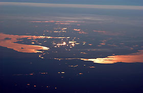
Titre : St. Petersburg and the Gulf of Finland
Description : (La description de cette image n'existe qu'en anglais)
This strongly oblique (from the side) view shows the Gulf of Finland and Lake Ladoga in the late afternoon. At this time of day, sunglint—the reflection of sunlight into the camera lens—distinguishes the bodies of water from their surroundings. The image was taken from the International Space Station when the craft orbited north of the Caspian Sea, approximately 2,500 kilometers (1600 miles) to the southeast on the Russia-Kazakhstan border. Lakes in Finland in the middle of the view are 3,000 kilometers (1900 miles) from the camera. The Neva River appears in sunglint, connecting Lake Ladoga to the gulf. Czar Peter the Great constructed St. Petersburg, starting in 1703, on the Neva River Delta. He established this city as his capital and window into Europe via the Baltic Sea. (Although not visible, St. Petersburg—the home town of Sergei Krikalev, Space Station commander when this picture was taken—lies on the Neva River delta.) In this view, taken with a powerful 400-millimeter lens, sunglint even reveals the causeways to Kotlin Island in the gulf—including some of the details of their construction. Oblique views reveal marked layers of gray haze generated by air pollution (top image, top of view), a common sight over Western Europe. Pollution also renders the bright glint areas a coppery color.
Below the photographs are a satellite view of St. Petersburg (left) and a map showing the location of the International Space Station at the time the photograph was taken (right).
|
|

